 |
| Map courtesy of the Ohio Department of Natural Resources. (Link) |

Now that we have the
context down, we can move onto another important factor. Pictured above is a
joint. A joint is a type of fracture, or a break in a rock. These are similar
to faults, but occur on a much smaller scale, and typically movement doesn't
occur along a joint as it does along a fault. A joint is a random break
in the rocks which occur when the bedrock faces some sort of stress, such as a
compressional force. When a joint forms, it creates a weak area in the rock,
which in turn can be more easily eroded by water. This feature is very
important when it comes to the formation of Old Man's Cave, as we'll see in a
minute.

The parking lot for
Old Man's Cave lies within a flat valley. This valley was carved out by Old
Man's Creek, the creek which ultimately runs through Old Man's Cave. This creek
eroded its way through what is called the Logan Formation. The Logan Formation
is a set of relatively soft rock layers, and so the creek was able to erode it easily and carve out
a broad valley with no cliffs. Eventually it got down to the Cuyahoga
Formation. This is the bedrock group which contains the Blackhand Sandstone.
Blackhand Sandstone is much, much harder than the Logan Formation rocks, and so
it is harder to erode. Once Old Man's Creek got down to this layer, it couldn't
easily erode the sandstone. However, it eventually found a large master joint
in the Blackhand Sandstone. The water seeped into this joint and over millions
of years slowly widened the joint. This widening joint eventually became the
gorge. Looking at the picture above, the rock exposed is the top part of
Blackhand Sandstone. This small waterfall is the beginning of the Old Man's
Cave Gorge.


Just a dozen yards
downstream, the creek encounters another interesting feature. Pictured above is
The Devil's Bathtub, which is actually a pothole. Basically, there was a weak
area that the creek found and eroded. Sand and pebble particles in the water
fell into this tiny eroded section and the current made them swirl around and
around. This swirling action carved a bigger and bigger hole, forming what we
now call The Devil's Bathtub.

This pothole filled
up and overflowed, eventually carving out a small notch in the top of the
pothole. When the creek has enough water flow (which it does for most of the
year, save the dry parts of summer), the water drains from this notch into the
tight channel pictured above.

The creek then gently
meanders its way down the gorge, like in the section pictured above. Here we
can also see many Eastern Hemlock trees. This species, along with other plant species
such as Canada Yew and Yellow Birch, are species normally found farther north
in cooler climates. During the last glaciation event, Ohio was much, much
cooler than it is today. Plant communities characteristic of cooler locations
(such as Canada) moved southward in order to survive. As the glaciers receded,
most of these plants in Ohio died out and temperate forest plants came back from their
Gulf Coast refugia and recolonized the area. However, some of these northerly
species remained in a few select areas of Ohio. Deep gorges like this one
create a much cooler microclimate, which allows these northerly plants to
persist. If you've ever been to Old Man's Cave on a hot summer day, you
probably know how nice and cool it is within the gorge.
 |
| As always, you can click on the photo to enlarge it! |
As we approach the
middle of the gorge, I'd like to take a quick tangent and talk a little bit
more about some features of Blackhand Sandstone. It's a complex rock
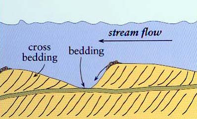
formation with many interesting features, such as cross-bedding. Cross-bedding
is layering at an angle to the main bedding plane. Essentially, sedimentary
rocks have one horizontal layer after another. Cross-bedding is an inclined
layering which reflects certain sediment features that were inclined. As I
mentioned before, Blackhand Sandstone was originally sand deposited in a
braided stream. Braided streams have characteristic sand bars in between the
water channels (example). These sand bars were created when the
water flow pushed sand up a slight incline before the sand settled down on the
downslope of that incline. A diagram at this process can be seen at this
link. This results in cross-bedded sand bars. These sand bars were
preserved throughout the rock bed, creating very exceptional examples of
cross-bedding in the gorge. To recognize these cross-beds, look at the
cliffsides and look for angled layers. If you look at the photo above, you can
see a part of a cliffside featuring normal bedding along with cross-bedding. On
the left side is what it looks like, while on the right I have outlined the
different sections along with the direction of incline in order to make the
cross-bedding more apparent.

Another feature of
the Blackhand Sandstone is conglomerate bands. Conglomerate is a type of
sedimentary rock that is composed of gravel-sized sediments. In the case of
Blackhand Sandstone, these gravel-sized particles consist primarily of quartz.
You can see multiple bands of conglomerate running through the sandstone in the
photo above. This gravel is typically laid down in the center of a stream
channel. Water in the center of a channel is moving the fastest; as a result of
this, small particles remain suspended in the water. Larger particles, such as
gravel, weigh enough to settle out of the water and deposit on the bed of the
stream. Essentially, the faster water flows, the larger the particles that are
deposited. Since Blackhand Sandstone was originally deposited as a braided
stream with channels and sand bars of assorted sizes, the resulting sandstone
consists of varying bands of cross-beds and conglomerate bands along with normal sandstone bedding. These
conglomerate bands can be seen throughout the gorge in various locations, so
keep an eye out!

The previous two
features of Blackhand Sandstone had to deal with its depositional environment.
This next feature has to do with the subsequent erosion of the Blackhand Sandstone.
Pictured above is what is known as honeycomb weathering. Blackhand Sandstone is
very porous, meaning water particles can easily seep through the rock.
Throughout the sandstone are trace deposits of hard iron compounds. Seeping groundwater
has deposited some of these iron oxide particles in pore spaces between sand
grains, and that iron then makes the sandstone highly-cemented and very hard to
erode. As more groundwater seeps through and erodes the sandstone, you end up
getting this honeycomb pattern of cavities (less iron and more easily eroded)
and rib-like projections (more iron and less easily eroded). It makes for very
attractive sandstone. Anyway, back to the gorge!

Old Man's Cave Gorge
can be broken up into 3 regions. There's the Upper Gorge, Middle Gorge, and the
Lower Gorge. We're now entering the Middle Gorge. This region begins with a
long, gentle cascade of Old Man's Creek down bare rock, a rather abrupt
change from the gentle, sandy meander of the creek in the Upper Gorge. These
cascades are one of my favorite parts of the gorge!

The cascades
eventually lead to a small waterfall called Middle Falls, pictured in the
bottom right above. More impressive is the incredibly large recess cave located
above it. This recess cave is the "cave" of Old Man's Cave. This
recess cave is nearly 200 feet long, 50 feet high, and 75 feet deep! Recess
caves form throughout the Hocking Hills region, and they all form due to the same feature of Blackhand Sandstone. Blackhand Sandstone is broken up into 3 separate zones; there is
the upper zone, the middle zone, and the lower zone. The highly-cemented upper
zone is very resistant to erosion, as is the lower zone; however, the middle
zone consists of weakly-cemented particles and highly cross-bedded layers. This
makes it relatively soft and easy to erode. As I mentioned before, the
sandstone is porous and allows water to seep through it. The upper layer
doesn't erode much as groundwater moves through it, but the middle zone easily
erodes on the other hand, and as a result this tends to form these large recess
caves like the one above. The resistant upper zone forms the roof, while the
"cave" part moves farther and farther in as it erodes away.

After the creek
cascades over Middle Falls, it comes into contact with the highly-resistant
lower zone of Blackhand Sandstone. As a result, it has meandered over this
layer while eroding more and more of the middle zone because it couldn't erode down into the lower zone. The result was a gentle
widening of the gorge. Another big characteristic of this stretch of the gorge
are dozens of large slump blocks. These boulders are actually made up of the
resistant upper zone sandstone. As the middle zone eroded, the upper zone
remained and formed the roof, like in the previous photo. Eventually, the
weight of certain parts would become too much, and this stress would cause a
large slump block to break off and fall to the floor below. As this process
occurred over millions of years, more and more slump blocks began littering the
gorge floor.

Old Man's Creek
continued to flow on top of the resistant lower zone until it found yet another
joint to exploit. More erosion occurred, and Lower Falls was born. It is here
at the bottom of this recess cave that the Blackhand Sandstone members ends and
runs into the so-named Fairfield Shale, a much softer rock. The plunge pool
visible was created through the erosion of the Fairfield Shale. From here, Old
Man's Creek travels a broad valley until it meets up with Queer Creek. Queer
Creek is the stream which created nearby Cedar Falls, yet another section of
the Hocking Hills State Park.
Overall, the Gorge
Trail at Old Man's Cave is about half a mile long. Over the course of that half
mile, the gorge cuts through the entire thickness of Blackhand Sandstone. The
thickness of Blackhand Sandstone varies geographically, but in this specific
area it's about 130 feet thick, meaning from the very first tiny waterfall to
the plunge pool of Lower Falls is about a 130 foot drop. I'm currently on a massive geology kick, so expect to see more geology-themed posts over this winter! Hopefully you enjoyed
this long post, and thanks for reading!